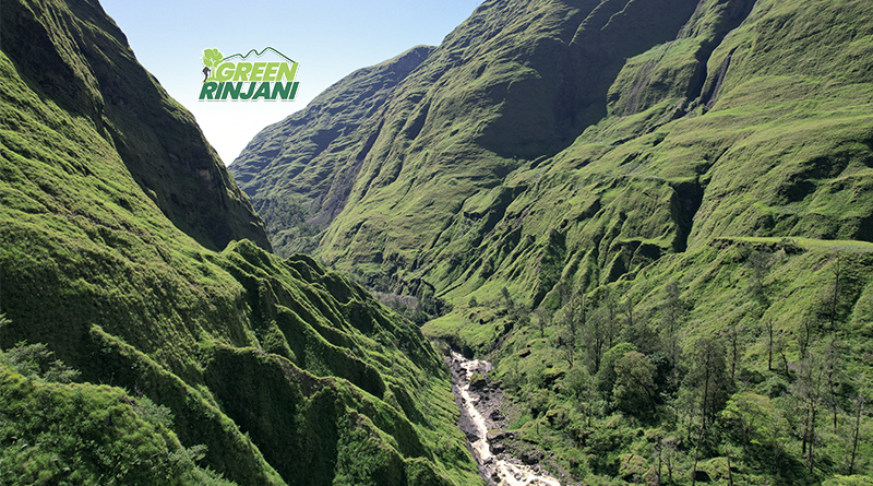
The Torean trekking routeis a scenic trail on Mount Rinjani in Lombok, Indonesia, officially opened to the public in 2021. Often described as looking like “Jurassic Park,” it follows a deep river valley system rather than climbing straight up the mountain slopes.
Key Features of the Torean Trekking Route
- Landscape: The trail is known for its dramatic scenery, featuring lush rainforests, narrow cliffside paths, and turquoise rivers.
- Main Highlights:
- Penimbungan Waterfall: A massive, iconic waterfall visible from across the canyon.
- Hot Springs: Provides closer access to the Air Panas Aik Kalak natural hot springs near Segara Anak Lake.
- Gua Susu: A local cave often visited along this path.
- Difficulty: Rated as moderate to advanced. While it is more gradually sloping than the Senaru or Sembalun routes, it has technical sections with narrow paths (known as “jalan kurus”) and steep valley walls.
Common Itineraries (2026 Season)
The Torean route is most frequently used as a descent path to avoid repeated steep climbs, but it can be hiked in both directions.
- Sembalun to Torean (3D/2N or 4D/3N): Start in Sembalun village, summit the peak on Day 2, and descend through the Torean valley for a scenic finish.
- Senaru to Torean (3D/2N): A “jungle trek” focusing on the crater rim and lake without a summit attempt, exiting via the Torean valley.
- Torean to Sembalun (3D/2N): Start in Torean village for a tougher uphill start through the jungle to reach the lake on Day 1.
Practical Information
- Location: The trailhead begins at Torean Village in the North Lombok Regency.
- Best Time to Visit: The trail is officially open from April to January. May is considered the best time for lush, green landscapes and fewer crowds.
- Requirements: Hikers must register through the Rinjani National Park system and are subject to “zero waste” inspections to reduce plastic pollution
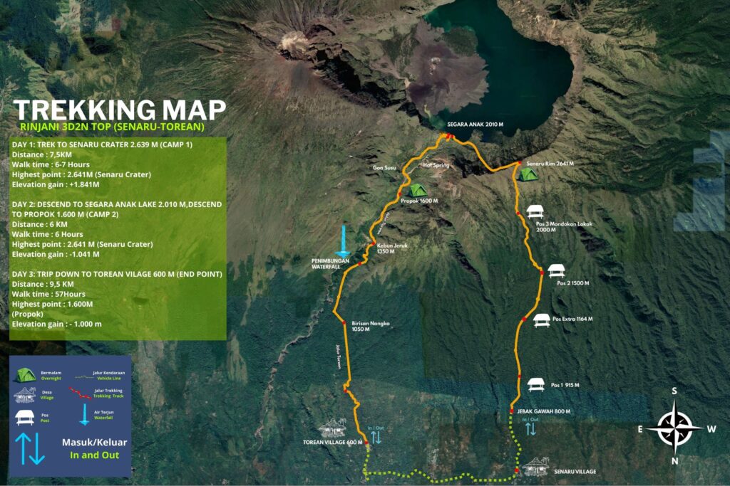
Torean Trekking Route Overview & Topography
- Starting Point: Torean Village (~600m above sea level).
- Total Distance: Approximately 11–13 km from the village to Segara Anak Lake.
- Elevation Gain:
- The trail climbs from 600m
- To the lake around 2,000m
- Ascents to the crater rim at ~2,600m.
- Maps typically show:
- Pos 1 (Torean Village): The entry point with registration posts.
- Pos 2 (Lokoq Gading): Jungle trek area.
- Propok Campsite: A common camping area at ~1,600m.
- Penimbungan Waterfall: A critical point where the path narrows significantly along a cliff.
- Segara Anak Lake: The final destination for the Torean section, connecting to the hot springs.